
The Commissioners of Irish Lights is a corporation chartered by the Irish Parliament in 1785 and based in Dublin, it continues to operate the major coastal lighthouses in Northern Ireland and in the Irish Republic.
Harbour Lights are operated by the local harbour authority.
Read on for further information and photographs of Irish Lighthouses
County Londonderry / Derry Lighthouses
Culmore Lighthouses
A 1920’s building with the station established in 1848. It has been inactive since 2012 and has a 7 meter concrete tower with a small window at the top which the light was formerly displayed.
The Lighthouse is painted white with a green base. The lighthouse stands at the end of a promontory projecting into the River Foyle south of its mouth, near Culmore Fort.
There is an active light with a focal plane of 4 meters a quick-flashing green light on a nearby post. Site probably open but the tower is closed. It is owned by Londonderry Port and Harbour Commissioners.
Ballynagard
An active lighthouse with a focal of plane 6 meters with a white flash every 3 seconds. A 7 meter concrete tower with a small window at the top through which the light was formerly displayed.
A current solar-powered light is mounted on top of the tower. The Lighthouse is painted white with a green base. Located on the west bank of the River Foyle at Ballynagard, about 1 mile southwest of the Culmore Light. The site and tower is closed as it is private property. Operator is Londonderry Port and Harbour Commissioners.
Coleraine Area Lighthouse
This lighthouse has been active from 1947 with a focal plane 6 meters. A red flash every 5 seconds and has a square pyramidal concrete tower attached to a small concrete shelter. Its entire structure is white and is located at the end of the east breakwater at the entrance to the River Bann. Accessible by walking the pier after a short trek through sand to the river mouth. Site open, however the tower is closed.
Portstewart Point
An active lighthouse with a focal plane of 21 meters It has a red light, 7 seconds on, 3 seconds off. Light is mounted on a 3 meters square concrete equipment hut, painted bright red.
A mast mounted on top of the hut, carried pilot signals. The lighthouse was repainted red in the winter of 2009. Located on the point, near the end of Harbour Road in Portstewart. The site is open but the tower is closed.
Causeway Coast Daybeacon (Storks Reef Beacon)
An inactive day beacon. It has 11 meters round stone beacon painted black with a red horizontal band. A historic beacon located in Bushmills Bay about 1 mile west of Portballintrae. Only accessible by boat. The tower is closed with the site open.

Rathlin West Lighthouse
Rathlin Island Lighthouses
Rathlin Island is an island off the coast of County Antrim in Northern Ireland, and is the only inhabited offshore island of Northern Ireland. With a population of approximately 130 people, and is the most northerly inhabited island off the coast of Ireland.
Rathlin Island is 3.5 miles from east to west, and 2 miles from north to south.
The highest point on the island is Slieveard, 137 metres above sea level. Rathlin is 14 miles from the Mull of Kintyre to the southern tip of Scotland’s Kintyre. Rathlin is part of the Causeway Coast and Glens area and is represented by the Rathlin Development & Community Association.
Rathlin Island is part of the district of Moyle.
Rathlin West
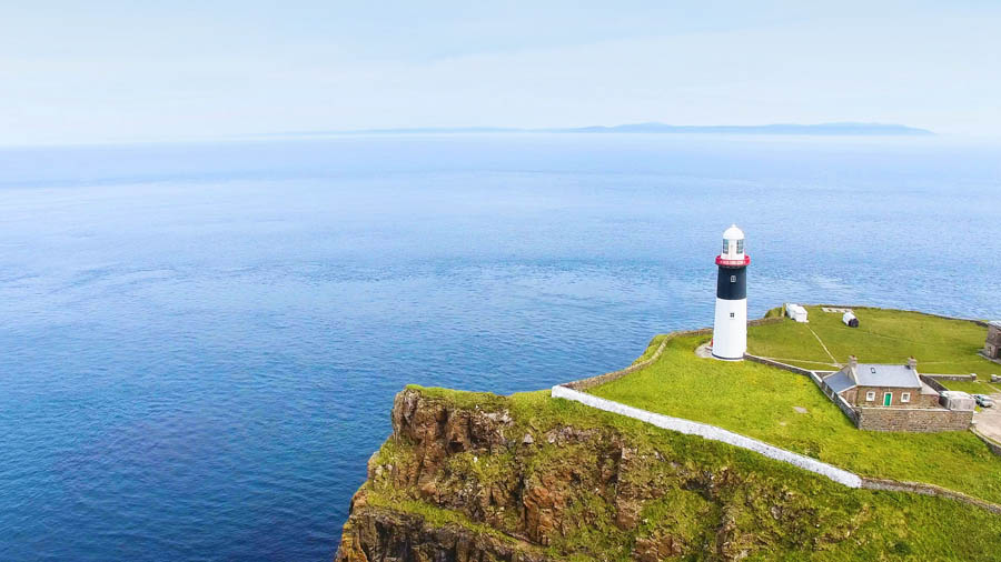
An active light with a focal plane of 62 meters and has a red flash every 5 seconds. Lantern on a concrete pad built into a notch in a steep cliff. Rising behind the lantern is a square cylindrical tower 18 m high, attached at its upper end to a 2-story keeper’s house set into another, higher notch. As its an upside down lighthouse the keepers climbed down to the light. The buildings are painted white for best contrast against the dark cliff face. The lighthouse is automated but it is maintained by an attendant.
Ireland’s famous “Upside-Down Lighthouse” has one of the world’s most spectacular settings. Building the station took three years and £400,000, The RSPB have a seabird observation platform atop the cliff close to the lighthouse. The lighthouse and birding centre were closed in 2014 for a £600,000 restoration. Located at the western end of the island.
The site is accessible by a single-track road which is also a hiking trail 5 mile long. During the summer shuttle bus service is available from the ferry dock. The site is an open birding centre and lighthouse, tours available daily April – September. The light operator is The Commissioners of Irish Lights (Rathlin West Lighthouse)
Rathlin East Altacarry Head (Low)
Built in 1856 and inactive since 1894. It has a 8 meter cylindrical cast iron lantern, painted white, with a narrow horizontal window through which a continuous white light was displayed.
The lantern is placed beside the high light.
Rathlin East Altacarry Head (High)
Active from 1856 with a focal plane of 74 meters with four white flashes, separated by 2.3 seconds every 20 seconds. It has a 27 meter stone tower with lantern and gallery, painted white with a black band just below the gallery. It has a 2-story and 1-story keeper’s houses with other buildings enclosed by a stone wall. The station is maintained by an attendant.
Ships entering the North Channel from the Atlantic must steer between this light and the Mull of Kintyre Light in Scotland. The site is historic for several reasons. In the cliffs below the lighthouse is a cave complex where Robert the Bruce of Scotland took refuge after being defeated by the English in 1306.
Also, Marconi made experimental radio transmissions from this site in 1898. Located at the north-eastern right-angle point of the island. It is accessible by a hiking trail.
Its site and tower are closed, but the lighthouse can be viewed from outside the wall. Operated by The Commissioners of Irish Lights.

Rue Point
This Light has been active from 1915 and has a focal plane of 16 meters, this lighthouse has two white flashes every 5 seconds. The 12 meters octagonal concrete tower without lantern light is displayed from a short mast.
The first light was destroyed by a storm in 1917, and the light was moved atop the fog signal tower until the present lighthouse was built. Its located on the south point of the island, accessible by a hiking trail. The site is open with the tower closed. The operator is The Commissioners of Irish Lights.

West Maidens Lighthouse
Larne Area Lighthouses
West Maidens
Built in 1829 but has been inactive since 1903. It has an 18 meter stone tower attached to a 2-story stone keeper’s house. Its lantern and gallery has been removed. Still serving as a daymark, the tower was previously painted red with a white band at the top.
The Maidens are a group of reefs and small rocky islands 12 miles northeast of Larne.
Located on a tiny island roughly half a mile west of the active East Maidens Light and is Accessible only by boat. Site and tower closed.

East Maidens Lighthouse
East Maidens
Developed in 1829 and is active with a focal plane of 28 meters. It has three white flashes every 15 seconds. Its 21 meter stone tower with lantern and gallery is attached to a 2-story stone keeper’s house. The lighthouse is painted white with a single black band.
The lighthouse is located on a small island near the east end of the group which is accessible only by boat. Its site and tower is closed. The operator is The Commissioners of Irish Lights.
Chaine Tower
Chaine Memorial Tower or ‘The Pencil’ as its locally known is an impressive beacon tower of Irish granite, built in 1889 as a memorial for James Chaine, the developer of Larne Harbour, with money raised by public subscription in Larne. It stands on the western side of Larne Lough at the entrance to the harbour which can be seen by visitors coming in by sea.
The Tower is an accurate replica of an Irish Round Tower and stands 28m high and 7 meters wide at its base. After a request from Mariners the tower was converted into a lighthouse by the Commissioners of Irish Lights in March 1898 and has stood like a sentinel over the Lough for over a hundred years. It is now owned by Larne local Council.
The tower light is active with a focal plane 23 meters light 2.5 seconds on, 2.5 s off, white or red depending on direction with the light shown through a window. The tower is floodlit at night.
From 1905 to 1935 the lighthouse was fuelled automatically with coal gas. The site open with the tower closed. Operated by Larne Harbour Ltd.

Ferris Point
The light station was established in 1838 which is now Inactive. It is approximately 15 meters square cylindrical tower supporting a large square glass-enclosed control room. The tower is painted white with the control room painted black.
This is the harbour control tower for Larne which is a major port with the Ferry to Cairnryan in Scotland and frequent shipping to many other major ports in Mainland Britain and Europe.
The tower replaced a traditional light station and formerly carried a navigational light. The light became redundant when a directional light was installed in the Chaine Tower on the other side of the harbour entrance.
The original light was described as a white tower and was in operation at least as late as 1994. Located at the east side of the narrow entrance to Larne Lough.
There are good views from ferries connecting Larne to several ports in Scotland. Site is open with the tower closed. The operator for this light is Larne Harbour Ltd.

P&O Ferry from Larne to Cairnryan 14th March 2019
Barr Point Fog Signal
This fog signal was installed in 1905 and was active untill 2006. It is 5 meters rectangular 1-story fog signal building, painted white. Located near Larne Golf Club, about 1/2 mile north of Ferris Point on the east side of the entrance to Larne Lough opposite the Chaine Tower. Its site and building is closed and is managed by Larne Golf Club.
Carrickfergus Area Lighthouses
Blackhead Antrim
Built in 1902 by William Douglass and is active with a focal plane of 45 meters. A white flash every 3 seconds with a 15 meters octagonal cylindrical granite tower with lantern and gallery.
It has a covered walkway to a two story keeper’s house with other buildings preserved. Three keeper’s houses are available for vacation rental.
In January 2010 the Environment Agency announced plans to list the station as a historic site.
In 2013 CIL announced plans to designate the light as one of the Great Lighthouses of Ireland and to develop the light station with accommodations for overnight rental.
Located atop a high cliff on a sharp headland at the northern entrance to Belfast Lough. Accessible by road and is about 2 miles north of White Head. Its site is open but the tower is closed. Its operator is The Commissioners of Irish Lights.

Blackhead Lighthouse Belfast Lough Landscape Co Antrim Northern Ireland
Belfast City Lightbeacon
Mew Island Lens
Built in 1887 with a decorative light displayed. This original F. Barbier hyper-radiant Fresnel lens was first installed at Tory Island in 1887 and was re-installed at Mew Island in 1928. In 2014 Irish Lights offered the large lens to the Titanic Foundation in Belfast and negotiations began on how it could be displayed. The lens was removed in November 2015. The Titanic Museum in Belfast applied to the Heritage Lottery Fund for funds to restore the lens and it went on display in March 2018 in a special structure on the Belfast waterfront. It is located in the Titanic Quarter and the Site is open.
County Down Lighthouses
Ards Area Lighthouses
Mew Island
Commissioned in 1884 which is active with a focal plane of 36 meters and has four white flashes, separated by 5 seconds every 30 seconds. Standing 36 meters it is a stucco-covered rubblestone tower with lantern and a gallery. It is painted black and white horizontal bands and has rubblestone keeper’s houses and other buildings. The great hyper-radiant Fresnel lens installed in 1927 was removed in 2013 and is on display in Belfast.
This lighthouse which replaced a lower tower on nearby Lesser Copeland Island, marks the beginning of the approach to Belfast for ships coming from the south and east. There were onshore keeper’s houses at Donaghadee. Located on Mew Island, a small island about 5 miles north of Donaghadee which is accessible only by boat.
Its site and tower is closed and is operated by The Commissioners of Irish Lights.
Copeland Island (Lighthouse Island)
Formed in 1815 with station established early 1700s. It has been Inactive since 1884. Its 5 meters stump and a 16 meters stone tower with the ruins of the keeper’s house and a modern house built as a bird observatory.
The lighthouse was abandoned in favour of the Mew Island Light to the north. The island is now owned by the National Trust and managed by the RSPB. Overnight accommodations are available. Located on Lesser Copeland Island, also called Lighthouse Island, an island just southwest of Mew Island and about 3 miles north of Donaghadee. Accessible only by boat. The site is open, but the tower is closed. Owned by the National Trust Northern Ireland and the site manager is Copeland Bird Observatory.
Donaghadee lighthouse
Built in 1837 this active light has a focal plane of 17 m and its white light is 2 s on, 2 s off with a red light shown over shallow water along the shore to the southeast. The 16 meters limestone tower, lantern and gallery is painted white. A fog siren blast every 12 s sounds only when ships are expected.
The lighthouse was repaired after being heavily damaged by fire in May 1900. In October 1935 the light was the first in Ireland to be converted to electric. Located at the end of the South Pier at Donaghadee, 9 miles east of Bangor. Accessible by walking the pier with the site is open and the tower is closed. Its operator is The Commissioners of Irish Lights.

Donaghadee lighthouse
South Rock at Kilwarlin
Commissioned in 1797 by Thomas Rogers, it has been m inactive since 1877. It is an 18 meter round granite tower with gallery and no lantern. This is the oldest surviving wave swept lighthouse in Ireland and is one of the oldest in the world. It was originally called the Kilwarlin lighthouse after its chief patron, Lord Kilwarlin.
The lighthouse was replaced by the South Rock Lightship in 1877. In 2009 the South Rock lightship was withdrawn and replaced by a large super buoy. Located off Portavogie and about 2 miles northeast of Kearney. Its accessible only by boat. Its site and tower is closed and is owned by The Commissioners of Irish Lights.
Newcastle Shore Station
Built in 1820 and was closed in 1905. It has four keeper’s houses, three built in 1821 and the fourth in 1862. These cottages housed families of keepers of the offshore South Rock Light.
After the lighthouse was deactivated in 1877, they housed off-duty crew members of the South Rock Lightship. The houses survive in private ownership. Located in Newcastle, north of Kearney on the Ards Peninsula. It was owner/site managed
Pladdy Lug
This station was established at least by 1782 and had a unlit day beacon of 10 meters. An octagonal cylindrical stone tower with a stepped pyramidal top, faced with white-glazed brick.
The reef was originally marked by a post. A stone beacon built in 1875 was washed away in 1884 and was replaced with another perch. The present tower was built after that perch was washed away by a storm in 1925. Located at the western end of a dangerous reef extending from Ballyquinton Point on the east side of the entrance to Strangford Lough. It is accessible only by boat. Its site is open with the tower closed.
Down Area Lighthouses
Lightship Petrel at Ballydorn
Built in 1915 and decommissioned 1968 standing at 34 meters this single-masted steel lightship was shown from a large lantern atop the mainmast and the entire ship was painted red.
Built at the Dublin Dockyard, the ship served on numerous stations in Irish waters. Its last station was off the River Blackwater, Wexford.
After decommissioning, the ship was first sold to Hammond Lane Foundries, which then resold her to the Down Cruising Club. The ship has been the club’s headquarters since 1969.
In 2014 it was registered as a historic vessel. It is berthed near Ballydorn, northeast of Killinchy, on the west side of Strangford Lough. The vessel is open only to club members and guests and is owner managed.
Killyleagh Town Rock
In 2011 a light was added to 19th century tower which is active with a focal plane of 3 meters.
It omits two flashes every 5 s, a white, red or green depending on direction. It has an 8 meter round cylindrical red brick tower. Fires were sometimes lit atop this beacon, but it was primarily a day beacon until the modern directional light was added in 2011.
Located in Stangford Lough about 250 meters off Killyleagh which is accessible only by boat.
Its site is open though the tower is closed.
Lightship Petrel, Ballydorn,
Built in 1983 this active light has a focal plane of 15 m with a red flash every 5 s. It has a 13 m masonry tower with a gallery but no lantern. It is painted white with a red band at the top with a solar-powered VLB 38 lens. This tower was built as a day beacon sometime in the late nineteenth century and there are mentions of it as early as 1885.
A 1917 coast pilot asserts that the tower was originally intended to be for a lighthouse. Located on a low rocky islet off The Narrows, the entrance to Strangford Lough, southeast of Strangford. Accessible only by boat. The site and tower is closed and the operator is The Commissioners of Irish Lights.
Ardglass Pier
Built in 1885 and a new station established 1813 this active lighthouse has a focal plane at 10 meters, directional light is 2 seconds on, 2 s off, white, red or green depending on direction.
It has a 10 meter cylindrical cast iron tower with domed lantern and gallery, painted white, mounted on a large concrete base.
The original lighthouse is said to have blown down in a storm in 1837. Findlay’s 1878 light list has a light at the harbour with an establishment date of 1850. Located at the end of the North Pier at Ardglass and is accessible by walking the pier which serves as a dock for the local fishing fleet.
Its site is open and the tower is closed. The operator is Northern Ireland Fishery Harbour Authority.
St. John’s Point
Commissioned in 1844 and added height nearly tripled in 1893. An active light with a focal plane at 37 meters and two quick white flashes every 7.5 s. There is an auxiliary light at a focal plane of 14 m showing a white or red flash, depending on direction, every 3 s. The light is also shown by day in foggy weather. It has a 39.5 meter tower with lantern and gallery and a bivalve Fresnel lens.
Its tower painted with black and yellow horizontal bands with a lantern painted white. It has Four keeper’s houses, one of them is occupied by a resident keeper, one is used for storage, and the other two are available for accommodations.
The fog horn was deactivated in 2011.
This is one of CIL’s Twelve Great Lighthouses of Ireland. The original lighthouse, designed by George Halpin, had a height of 13 meters. One of the most complete light stations surviving in Ireland. In 2012 CIL’s announced plans to develop the light station with accommodations for rental. In 2015 CIL announced plans to replace the historic rotating Fresnel lens with a modern LED light. This sparked protests throughout the area. In response to the uproar, CIL agreed to postpone any change while engineers study other ways to safely remove the mercury used to rotate the lens.
The two keeper’s houses were renovated in 2015 and opened for vacation rental in 2017. Located about 2 miles south of Killough, marking the entrance to Dundrum Bay. Accessible by a walk from the end of the road, where parking is available. Its site and tower are closed, but the lighthouse can be viewed from outside the building. Its operator is the commissioners of Irish Lights from St. John’s Point Lighthouse. Its site is managed by keepers houses, Irish Landmark Trust.
Newry and Mourne Area Lighthouses Annalong
Commissioned in the 1820’s this light has been inactive for many years. It is approximately 5 meters round white stone tower. Located on the south side of the Annalong River in Annalong.
Its site and tower are closed and is private property, however the light can be seen from nearby.
Cranfield Point
Commissioned in 1803 though it has been inactive since 1824 this is a stone lighthouse on Cranfield Point which marked the entrance to Carlingford Lough, before the Haulbowline lighthouse was built. The lighthouse was lost to beach erosion in the 1861 but the keeper’s house continued in use as a shore station for Haulbowline until 1921. The house survives today in private ownership. Located on the north side of the entrance to the lough this is the southernmost point of Northern Ireland. Its site and tower are closed as it is private property.
Haulbowline
This light was built in 1823 and is active with a focal plane of 32 meters with three white flashes every 10 seconds. This is a 33 meters tapered granite tower with lantern and gallery, incorporating keeper’s quarters and is resting on a square base. The former fog horn was deactivated in 2008. The tower is unpainted with its lantern painted white. Until 1921 this lantern displayed a ‘half tide’ light to inform mariners that the tide was high enough for vessels to enter the lough. In addition, from 1873 to 2007 a continuous red turning light marking the start of the Carlingford Lough entrance was displayed from one of the lower windows of the tower. This lighthouse is built on a dangerous rock, exposed only at low tide.
The shore station was at Cranfield Point until 1922 and then at Greencastle. This was the first Irish offshore light to be automated in 1965. Located in the middle of the entrance to Carlingford Lough, just at the northern side of the border between the Republic of Ireland and Northern Ireland. Accessible only by boat. The site and tower are closed and its operator is The commissioners of Irish Lights.
Haulbowline Range Front (Vidal Bank)
The date of this light is unknown and is active with a focal plane of 7 meters, its white light occults once every 3 s. Its 8 meter octagonal skeletal tower with square metal watch equipment room is topped by a gallery. It has a red triangular daymark on the range line, its upper portion of tower is painted white, the lower portion is green. Located about half a mile northwest of the Haulbowline lighthouse it is accessible only by boat however it has good views from the Northern Ireland shore near Cranfield Point. The site and tower are closed and its operator is The Commissioners of Irish Lights.
Haulbowline Range Rear (Green Island)
Another light with an unknown date. With an active focal plane of 12 meters this lighthouse emits a white light occulting once every 3 s. It is a 14 meter octagonal skeletal tower with a square metal watch equipment room, topped by a gallery. It has a red triangular daymark on the range line.
The upper third of the tower is painted white with the lower two thirds green.
Located in Carlingford Lough about half a mile west northwest of the front light. It is only accessible by boat but has good views from the Northern Ireland shore near Cranfield Point.
Its site and tower are closed.
It is looked after by The Commissioners of Irish Lights.
Are you visiting Northern Ireland?
For more infornattion on N.I. click Here
Rathlin Community click Here
Discover Northern Ireland click Here
Northern Ireland on Tripadvisor click Here
For more infornattion on Rathlin Nature Reserve click Here
Looking for a tour guide? Shutter speed Ireland can reccomend Milliken Tours Ireland
A professional, family run tour group who will go that extra yard to make your visit to our country fun filled and memorable.
Contact them Here


